


gap_vizille-oct2023

aeldin
User
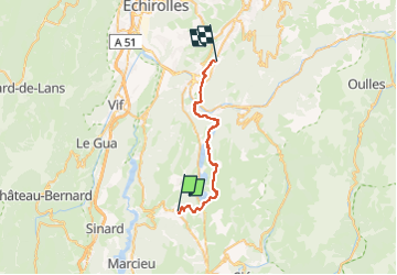

Length
28 km

Max alt
1245 m

Uphill gradient
643 m
Km-Effort
38 km

Min alt
278 m

Downhill gradient
1300 m
Boucle
No
Creation date :
2024-09-19 18:16:00.429
Updated on :
2024-09-25 21:06:36.672
5h03
Difficulty : Difficult

FREE GPS app for hiking
 SityTrail
IGN / Geographical institutes
SityTrail Plus
The world is yours!
About
Trail Horseback riding of 28 km to be discovered at Auvergne-Rhône-Alpes, Isère, La Motte-d'Aveillans. This trail is proposed by aeldin.

Positioning
Country:
France
Region :
Auvergne-Rhône-Alpes
Department/Province :
Isère
Municipality :
La Motte-d'Aveillans
Location:
Unknown
Start:(Dec)
Start:(UTM)
716647 ; 4982484 (31T) N.
Comments